


tête de torraz

Louna
User
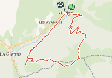

Length
11.6 km

Max alt
1922 m

Uphill gradient
747 m
Km-Effort
22 km

Min alt
1198 m

Downhill gradient
743 m
Boucle
Yes
Creation date :
2021-10-19 07:37:27.585
Updated on :
2021-10-19 16:27:06.856
3h33
Difficulty : Very difficult

FREE GPS app for hiking
 SityTrail
IGN / Geographical institutes
SityTrail Plus
The world is yours!
About
Trail Walking of 11.6 km to be discovered at Auvergne-Rhône-Alpes, Savoy, La Giettaz. This trail is proposed by Louna .
Positioning
Country:
France
Region :
Auvergne-Rhône-Alpes
Department/Province :
Savoy
Municipality :
La Giettaz
Location:
Unknown
Start:(Dec)
Start:(UTM)
308020 ; 5083569 (32T) N.
Comments